A nice easy cruise on a glorious, sunny day in New Zealand. Long live holidays!
 |
| Sit back, relax, and enjoy the voyage! |
 |
| Leaving port |
I have always loved ferry trips, which may sound a bit weird considering that seasickness is a real and very life-threatening condition. Well, real at least, but to anyone that has experienced it in full swing (so to speak), will no doubt agree with me that you feel like you will die. There are many different types of ferries though, from a Sydney Rivercat up the Parramatta River that cruises along smoothly like a hot knife through butter, to the rollercoaster classic trip of Circular Quay to Manly during rough weather, waves and wind lashing at anyone brave enough to be outside. These are tame compared to what you get on the open seas. I once caught the ferry from Barcelona to Ibiza, which was lovely, and I even slept (as it was overnight). The way back, however, was a maritime disaster of epic proportions, with the puke-O-meter on full projectile. It was a car ferry, but nothing huge, and being a catamaran, you’d think it would be smooth sailing. However, when people got on and did their usual thing of eat and drink immediately (like a 1-hour flight, people just need to stuff themselves), I was worried – I never eat on a ferry until I know she isn’t gonna hit waves.
 |
| Seasickness is not fun! |
The person I was travelling with wanted something to eat, but I warned them to wait. We did. Then it happened. One person ducked unsteadily to the bathroom. Followed by another, then another, then the first person again. There was vomit washing back and forth along the floor, people going on the carpet because they got caught short. Even the crew go into the act – by the end, about 90% of everyone on board had lost their breakfast, lunch, dinner, and any food from every time they’d ever eaten. Not me; I fell asleep in my chair. A family had also fallen asleep, laying down on the floor with their feet point towards the front of the ferry. They explained to me afterwards that seasickness is not about eating, or even your stomach, but rather your balance and inner ear, so laying flat helps this balance. I have been very sick on a smaller boat just outside the Sydney Heads, while scuba diving with sharks, so I wasn’t immune. So, stepping onto this ferry, I sized it up, checked out the bathrooms and closest door to the fresh air, and decided it was safe and not rockable. I did not head straight for the restaurant though. We left port a little later than expected, setting sail out of beautiful Wellington at 2:30 instead of 1pm, and the journey between the North and South Island was going to about 4 hours, a nice easy cruise on a glorious, sunny day in New Zealand. Long live holidays!
 |
| Green hills on the South Island |
 |
| Some tucked away houses |
 |
| Pulling into port at Picton |
 |
| Vineyards just outside of Kaikaoura |
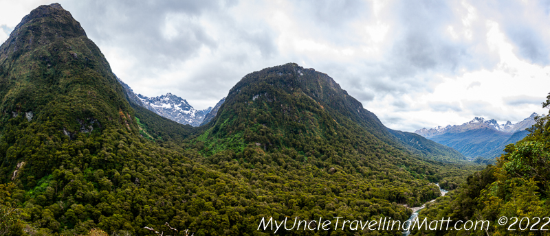
The ferry was very smooth, the sun was shining, so it was a very pleasant trip across the Cook Strait. There are two kinds of people on boat trips – those that chill in their seats, reading books, looking at phones, chatting; then there is the other type, getting up to see the boat leave, the water slapping the sides, the wake left by the ship, then rushing up to the front to get the best view. Maybe the second type is just kids… and me. It wasn’t long before we’d passed the southern tip of the North Island, and by this time the South Island was already visible. I was outside most of the time, enjoying the weather and the views, watching the land slip by. Along the wild coast of the top of the South Island there were small houses built right up on the shore, little farmsteads and wooden cottages on stilts, all with property and views included, and some even with private piers. The landscape was rugged, hilly, but very beautiful, and not even the wind turbines on top of the ridge line could take that that away.
 |
| Our amazing (and free!) campsite near Kaikoura |
While standing outside on the railings, I got talking to an older bloke who was coming down for his daughter’s wedding. He was quiet, polite, but full of info about the local area, as he’d been here a few times. He was lovely and even took a photo of us - a rare thing as I hardly ever hand my camera over. The ship pulled up in Picton after 4 hours of smooth sailing, and we drove right off, through the town, and onto our stopping point for the night. It was nearly dusk already, as it was about 6:30pm, so we needed to find a place to stay, and make dinner while we could. I did have a place in mind, and it was a new campsite on the beach with facilities and even a shop and restaurant. It was called Kekerengu, and we got there at about 7:45pm. However, there was nobody there at the shop, a few people at the campsite, and I wasn’t sure what to do. Although we hadn’t booked, I was expecting to pay, but figured there was nothing I could do till morning. We parked up, made dinner, and enjoyed a sunset while watching the waves crash against the coast. It was so picturesque here, and was the best camping spot we’d stopped at so far. There were even facilities on-site, including flushing toilets (a real luxury while camping!) and hot showers. Yes, hot showers! It was coin operated, which out in the middle of nowhere for a couple of cashless travellers (who uses cash after the pandemic?), would have made us showerless travellers as well. Luckily for us, we’d met Bruce a few days back in that funny little campsite before Wellington, and had taken some cash out. Bruce you are a legend! Hot showers were taken quickly in fear of the timer running out, but it just kept going, so after business was attended to, we could enjoy the steady flow of hot water. We decided to end the shower before the water stopped, as I wasn’t sure it would, and wanted to leave water for other people in case it was tank water. Warm, fed, and parked up in a beautiful spot, we crashed early, listening to the waves as we fell asleep.
 |
| Beautiful Kaikoura! |
 |
| Hello Mr (or Ms) Seal! |
 |
| Seals love sunbaking |
 |
| Watching dolphins in Kaikoura |
We woke up early, packed up and headed off. We stopped off by the café to see if there was anyone to pay, but it seemed like they were sleeping in. We tried. Our next stop would be Kaikoura, a gorgeous little coastal town famous for its beaches and seal colony. An hour of driving and we reached Kaikoura, which is nestled between the mountains, green forests, and the ocean. I visited this place for the first time way back in 2007 and I remembered the great fish and chips, so I knew exactly what we’d be having for lunch today. The other thing was the seals, which live just outside of town in a colony beneath tall, chalky cliffs. We cruised through town, passing little arts and crafts stores, and the place had a lot more tourists than I remember from 2007. Everywhere gets popular eventually, and this place is a true hidden gem of New Zealand. We spotted the fish and chips place, which was already busy, but wanted to see the seals before lunch, so continued on. We parked at the seal colony, and a dense mist had moved in from the sea and come right up to the land. It was hard to see much, but the sky was still blue, and I’m sure the seals were out there somewhere. We walked right out onto the rocks, not following a trail or anything, searching for the cute little New Zealand Fur Seals that we came for. It wasn’t long that we began to see little brown blobs through the mist, becoming clearer as we can closer. There was some seals that were sleeping, some were sitting up and looking at us, while there was also one noisy one who was barking and showing his teeth. There is nothing to worry about, seals aren’t normally aggressive, as long as you don’t get too close.
 |
| Our van in Kaikoura |
Another thing you need to be mindful of is their escape route – these little guys will always try and run away first, so don’t get between them and the sea, or you might get between their teeth. We also walked along the clifftop, to get more of a bird’s eye view of the area. The fog moved in and out, sometimes obscuring everything but the path 2 metres ahead, then it would open up and you could see the green paddocks, the blue sky, the sea out to the horizon. From this vantage point, you also go to smell the gull colony, which stank almost like rotten fish, possibly made worse by all the seals lying out in the sun (and using dry land to poo). We walked back to the car, very happy with what we’d seen, along with some great photos. Just before we got in the car, there was a little commotion in the water - we went over to the edge of the water, climbing the rocks to get where other people were watching something, and then we saw them - a large pod of dolphins jumping and splashing around. They must have been fishing as a family, and it was amazing to watch - sadly too far away and too quick for any decent photos, but still an experience. There is so much wildlife in a small stretch of land (or sea). It was lunch time, so we headed back to town to tuck into the ‘World Famous Fish and Chips’ of Cooper's Catch that I’d been craving all day. Let me tell you, it did not disappoint – cheap, plenty of food, friendly service, and outdoor seating with free parking for customers. The seagulls did not get a feed.
 |
| Don't get between seals and their escape route (the water) |
 |
| The wild and beautiful cost around Kaikoura |
 |
| The beach just outside of Christchurch |
 |
| As advertised - world famous! |
The day was half over, but all that was planned for the afternoon was to drive south to Christchurch and get some accommodation. As we drove, we passed some absolutely stunning scenery – the area around Kaikoura is full of beaches, mountains, and green rolling hills in between, with enough sheep, cows and farmhouses to make a landscape renaissance painter wet their pants. There were even a few vineyards, all planted in neat rows, and full of green leaves, but no grapes as yet. We arrived at Christchurch at about 4:30pm and found a nice little campsite within a few blocks of the beach. This campsite was a paid one, a small family-owned and run business in South Brighton, which sat on a peninsula of land between the ocean and Christchurch. We would be exploring the city tomorrow, but decided today would be a relaxing afternoon, a walk on the beach and a bit of grocery shopping for dinner and lunch the next day. We set up camp (parked the van), then went for a walk along the beach on our way to the supermarket. The weather wasn’t warm enough for a swim, but it was a good stretch of beach for walking and playing with dogs. There were a few keen mutts running into the waves chasing down sticks thrown by their owners, but nobody swimming at all. It was still a nice walk, but then we go to South Brighton, and what we saw there was a little depressing.
 |
| Caution! Seals! |
The town had clearly seen better days, and half of the stores were boarded up and closed. There was graffiti on plenty of walls, but not the cool street art type graffiti, but more tagging and sloppy spraying that anything else. I’m not sure if it was because of Covid, and the place had never really sprung back to life, or maybe the earthquakes that hit Christchurch, but there was a real air of disappointment and almost despair, as if a wonderful seaside town that was once bustling, colourful and full of live had died gradually and painfully. There were quite a few bored teenagers hanging around, without the energy to even cause trouble, as well as a few drunks and homeless people. Everyone else was either at home, in a pub, or in a hurry to get to either of these places. I’m sorry South Brighton, I hope a new mayor comes in, or something else that brings changes to breathe life back into you soon – I could see there was something there once and it would be a shame to lose that forever. I have to move on from this depressing subject, so I will talk about the supermarket. There are two main chains of supermarkets in New Zealand, New World and Countdown. The first company is a locally owned one, and we were frequent visitors, as they had NZ brands, decent coffee, and also free Wi-Fi for 30 mins, which we used to catch up on the world. Countdown, on the other hand, is Australian owned, and called Woolworths back home (and they haven’t changed the logo either). Its pretty much like the Big Two in Australia, where the prices and look of the shops are ‘same same but different.’ We got out shopping from Countdown today, and walked back for dinner.
 |
| Green hills and tall mountains - pure New Zealand! |
 |
| The colours of Kaikoura |
 |
| Christchurch tram and the cathedral |
 |
| Trams about town |
We got into Christchurch the next morning, and were looking forward to walking around the city, but the clouds had moved in, with rain looking likely. We needed to do some shopping for souvenirs as well as get some cooking gas, as our bottle run dry after (just) making dinner. Unfortunately, New Zealand towns all look the same from the main roads; strip malls, car dealerships, fast food chains, and nothing to see. Christchurch, however, was different as soon as you passed the ring road (or bypass road) and go to the centre. Unique to this city are its grey stone buildings, which include the cathedral, as well as some public buildings and many of the educational institutions. I’m not sure why this stone, but I’m guessing these buildings were all constructed around the same time, much like Sydney’s sandstone buildings that were built between 1850 and 1900 (Sydney Uni – 1850; Sydney Town Hall – 1869; The QVB – 1893). We stopped for coffee just outside the cathedral, after having found a safe and free parking spot. The coffee shop was a little food truck-style outlet, and served coffee in five sizes: eeny, meeny, miney, moe, and teeny weeny. I felt silly asking for it, but ordered two flat white mineys (or should that be two miney flat whites?).
 |
| Dance like nobody is watching |
Sadly, the cathedral had taken some damage in the 2011 quake, which also killed 185, but restoration was well under way, so it wouldn’t belong before she was back in once piece. I couldn’t remember how bad the quake had been, so looked it up, and it was a serious one – 6.3 and causing extensive damage in the city. We saw some of the damage that hadn’t been fixed, and it did look like the city was still recovering from this natural disaster. I have to note that the city had plenty of rubble and empty spaces where buildings used to be, but they had some great graffiti to cover up the sore spots. One art installation that I have to mention was the Dance-O-Mat – a small square surrounded by damaged buildings covered in graffiti, but with a coin-operated, bluetooth speaker-jukebox. All you need to do is slot in $2 into the old washing machine and off you go with your own music for 30 mins of boogie time! We had a quick dance like nobody was watching, pulling out all the dance moves (including an attempted moon walk), before the coffee wore off and we needed to slow it down a bit. The centre of Christchurch has some nice cafes and restaurants, but it mainly a smaller version of any city, with glass frontage for brand name stores that you get anywhere. To see the important stuff in the city, you can grab an old tram that runs in a loop around the centre. We got what we needed to do, which was some food shopping and some gifts for back home, then decided to walk back to the car before the rain made it miserable to walk. We got back to the van just in time, as the rain had really settled in. We were stocked up and ready to roll out, with the next stop being Mt Cook and the lakes along the way. I enjoyed Christchurch, but I’m always more exited by seeing some mountains and wilderness.
 |
| The vista from Lake Tekapo |
 |
| Amazing, even on an overcast day |
 |
| The colourful and Insta-popular Lupin flower |
 |
| Welcome to Lake Tekapo |
We stopped off in Geraldine for petrol and a late lunch, before continuing on the Lake Tekapo. This road west was very beautiful, golden fields with green hills that were changing into mountains, with plenty of open spaces and not many people. There were a few little towns along this road, including Burke’s Pass, which apart from the stunning scenery typical of a mountain pass, had some great stores, including a ye olde petrol station full of fuel and road signs. Unfortunately, we only drove past, not wanting to stop as the weather was closing in a little and we wanted to see the main attractions for today – Lake Tekapo and Mt Cook. We came down from the pass and hit the lake – and my heart rate jumped! It had been a long time since I’d been here, but even so, my memory of this place was such a good one that it made me almost twice as excited.
 |
| The church of The Good Shepheard |
The waters of the lake are a glacial blue colour, with darker or lighter patches with the sunlight, but very hard to tell how deep at any point. Ringed by mountains, slopping down with pine trees all the way to the lakes edge, Lake Tekapo is a postcard scene, and one that you just have to stop for numerous times to appreciate. We pulled over in a small carpark, jumped out, and started taking photos. Everyone did this, and I think if they built a pedestrian crossing at this point, the traffic would bank up for miles! From here we could see the snow-capped mountain range, including Mt Cook (just!), but the clouds were making the view both better (dramatic effect) and worse (too much drama) at the same time; I wasn’t sure how long it would be before it rained and ruined everything. We got back in the van and headed just down the road to the Church of the Good Shepherd, which is the main stopping point for the lake, and where we’d find the most tourists. The area is very nice though, and worth the stop, as apart from the great views of the lake, you also get to see a picturesque stone church that sits on a slight rise and looks out over the lake. The whole grassy area around the carpark and church is full of brightly coloured flowers, called Lupin flowers, which make an amazing splash of blue, purple and pink in front of the blue lake and mountains. I remember seeing these flowers, or ones very similar at least, in southern Chile in the Torres del Paine area, so they must grow in colder highlands. Unfortunately, most patches of these flower were covered in tourists, trying to get that amazing shot for Instagram. People were pulling all sorts of poses, much like people at the Leaning Tower in Pisa. One girl had even fallen right in the middle of them to get a shot.

With the clouds really moving in now, and even a few drops of rain starting to fall, it was time to find out spot for the night. It wasn’t a long drive before we found our destination, Mackenzie Waitaki campsite, which is on a slight rise above Lake Pukaki (the next lake across). This was another free camping site, and had toilet facilities, which is a bonus, but sadly no shower like Kaikoura. So, we parked the van, made some hot soup for dinner, then nestled down for the night as the rain settled in. There were a few people here, in rental vans from a variety of companies, and some I was sure that we'd seen on our trip, like we were all going the same way. Travellers Autobahn, Juicy, and even Escape vans like ours were parked up front-row for the view of the lake and mountains. A few people also had their foldable camping chairs out and were enjoying a cuppa, watching the best show on tv - nature. Although we weren’t hopeful the weather would be great the next day, we couldn’t change our plan – we were heading north up the west side of the lake and onto Aoraki / Mount Cook National Park to hopefully see the mountain and do some walking.
 |
| Looking our over the lake towards Mount Cook National Park |
Remember
to also follow me on Instagram at: https://www.instagram.com/myuncletravellingmatt
MyUncleTravellingMatt.
November 2022.