Showing posts with label australia. Show all posts

Sunday, 19 May 2024

Kiama to Gerringong Coastal Walk


One of Australia’s most scenic walks
Looking south from Stanwell Tops


The Sea Cliff Bridge
September means the start of Spring in the Southern Hemisphere, so that means it’s time for so longer walking here in Sydney. Before I get started though, I need to mention how the seasons are tracked differently in Australia to Europe. In Australia, like the rest of the world, seasons are 3 months long, but in Europe, they mark the beginning and the end of them differently. Spring in Australia starts on the 1st of September, and ends with November, with summer starting on the first day of December. Simple. However, in Europe Autumn runs from the 23rd of September to 21 December 2023, which is based on the equinoxes (Spring and Autumn) and solstices (Summer and Winter). I always argued with people in Spain about when seasons started, as they follow the European way, and I had always known the simple 3 month to a season system. I know that the European way is probably the more accurate way of measuring, as it actually runs with the distance of the Earth from the Sun that actually determines the seasons, but I much prefer the easy way. Anyway, just a little factoid for anyone that is interested. So it was Spring in Australia, and with the days getting longer and the weather warming up a little, I decided it would be time for a longer walk. We’d already done plenty of walking along the coast in Sydney, but this time the walk would be a little further. Starting at Kiama, we were walking 2 sections of the Kiama Walk, the Mid Section from the Kiama Blowhole to Loves Bay, as well as the South Section, finishing at Gerringong. The Kiama Walk website says both parts are about 11 kms in total, and while stating that the grade is medium-hard, I think we could do it quite easily. Although I’d been to Kiama many times before (but not in ages), I had never done any part of this walk before, so a whole new coastal walk and whole new experience. The website also says that this walk is ‘one of Australia’s most scenic walks,’ and so it was looking forward to it even more!

Rock fishermen living on the edge

You can walk all around this amazing bridge - even under it!

Walking the Sea Cliff Bridge

It was an early start to the day - but what a sunrise!
For the sake of storytelling, I am going to combine a short day trip in the car done after the longer walk we did. The reason for this is because if you are driving to Kiama to do this walk, you must drive the more scenic and coastal road along the Sea Cliff Bridge. We did the walk before we had a car - we bought our great little Corolla in Dec 2022, a few months before this walk, and so missed out on this part of the trip because we were going by train. We left our house and jumped on the Prince’s Highway (which many people think is called the Princess highway), which runs south and out of the city. This big road starts at the edge of Newtown (our part of town) and runs all the way through suburbs like Rockdale and Kogarah, crossing over the George’s River via the Tom Ugly’s Bridge (named after the bit of land on the north side of the bridge, and possibly a guy called Tom Huxley 80 years before the 1927 bridge was built), and over into the Sutherland Shire. You keep going down past the Royal National Park on your right, but at this stage you’re still in Sydney – you don’t leave the city until you’re past Waterfall and meet endless trees either side of the road.  from freak waves.


Waiting for the blowhole to blow
The Royal National Park forms part of Sydney’s national park system, made up of half a dozen or so within the boundaries of the city – it includes the Sydney Harbour, Ku-ring-gai Chase, Botany Bay, and Lane Cove National Parks. The Royal though, was established in 1879, making it the world's second-oldest national park, but I will leave that adventure for another post. Today we headed out of the city, turned off the highway at Stanwell Tops, named this because of view from the top of the cliff (and maybe some guy called Stanwell as well). It’s from here that you can park your car, get out, and see all the way down the coast towards Wollongong. Such an amazing view, it always brings people no matter the weather, and I usually stop here before a big drive down the coast. I took a few pics, then we got back in the car and drove down through what seemed like a rainforest, and then joined up with the Grand Pacific Drive. This was the road that everyone took before the big main highway was built, and it winds its way around the coast, and is very scenic. The Sea Cliff Bridge was built in 2003, costing $52m and its main purpose was to allow cars to drive along the road without the risk of falling rocks, which was an issue with the old road that hugged the cliffs. We parked and walked along this bridge, admiring the views and the engineering feat. Its 40m above the crashing Pacific Ocean, and is just under 500m one way. The whole area around the bridge is beautiful, and if you have the time, explore a little more under and around the bridge too – but be careful on the rocks, lots of rock fisherman get washed off all the time from the freak waves.

Kiama is still mainly a fishing town

The rocky coast of Kiama

Watching the waves

Cheeky Corellas in Kiama
So that was a day trip a few months after Kiama, but it can be done with the same walk if you have car – just keep heading south. Back in September though, we got the train from Central down to Kiama, roughly 2.5 hours, to start our walk. It was an early start, early enough to see the sunrise from our balcony before heading to the station, and a nice train ride as well, especially when snippets of towns like Coaldale and Coalcliff are visible through the window, with the ever-present blue of the Pacific in the background. Kiama is a town on the South Coast of Sydney, and one that has very pleasant memories for me. As a kid, I would often come down here with my dad, feed the pelicans and see the blowhole. It was also a stopping point to another beachside town, Culburra, where I used to spend the school holidays with my grandmother and her sister-in-law. So all in all, one of my favourite places – although there is nothing particular special about it compared to other towns, there is for me. It hasn’t changed that much over the years either, which is a good thing, as the small shop-lined main street is charming, with a healthy mix of craft stores, independent fast-food places, a pub, and a historic building. On the other side of the road is the ocean, with grassy areas for relaxing on the foreshore. 


The relentless waves of Kiama and the South Coast
When in Kiama, if you don’t do anything else (and there’s not much to do otherwise), you should visit the famous Kiama Blowhole! The hole in the rocks, which is 2.5m wide, is the source of the attraction, as when the tide is just right, a stream of sea water shoots up to 30m above the rocks. This makes it the world’s largest blowhole (something I did not know before writing this), first seen by Europeans in 1797 by a whaler, and has attracted visitors for over 100 years and now has over 900,000 tourist visits a year. The weather was overcast, and the waves weren’t quite right, so we didn’t get to see anything above 5m, but I was not disappointed, as I just love Kiama. Some other people, however, were very disappointed, and every time they put their selfies stick down, a jet of water would shoot up behind them, and they’d miss it. The plume of water is created by the shape of the rock underneath the surface, where a large bowl or reservoir chamber fills up with water from the incoming surf, and then when that pushes back against the next big wave, there is nowhere else to go but up. This process is invisible to the viewers waiting for it to happen, but you hear the great thuuuaaamp as the waves come in and collide. The rock formation here is very interesting, and if you look hard enough, you can see that they are not ordinary rocks – the shape is something like The Giant’s Causeway with 6-sided basalt columns pushing up from the ocean. We continued on the walk, passing the lighthouse which stands guard over the rocky coast, and some noisy corellas playing on the grass.


Swim at your own risk!

Clouds over Kiama

Watching the Little Blow Hole

Perfect place for a picnic

Some people come here to sit and watch the waves, others to take photos of the blowhole, a few even for yoga/tai chi/meditation, but a lot of walkers come here too, just as we had. Following the coastal path, you can clearly see that the coastline here was formed by volcanic activity, even for a novice geologist like myself. Even though I haven’t been to Hawaii, I have seen photos, and Kiama looks a lot like what I’ve seen – dark volcanic rock, that once bubbles down from the volcanoes into the sea, with dark soil and vibrant green plants. Even the weather here is in a micro-climate, as it feels more humid that a coastal area should, but then again Kiama is squashed between the great Pacific and heavily forested hills – it rains often, but is hot and humid, so no wonder the South Coast is always so green (and makes great land for dairy!). Doing a bit of research after the visit, I discovered that there were volcanoes here – two in fact, which erupted from the Saddleback Mountain near Kiama 66 million and 200 million years ago (the second being before the dinosaurs even, give or take a few million years!).


Cliff walking
We walked past Kiama Surf Beach, which is aptly named as I think it looked a bit dangerous for swimming, and then Kendall’s Beach. The beaches here are beautiful, with jet blue waters and curling waves, yet dangerous, and there is signage warning of this. We continued around the headland towards the Little Blowhole, the little sister to Kiama’s. Although smaller (as the name suggests), it was quite active and made regular eruptions, surprising me and the people that had gathered to see it. There was no loud noise as the water came in, and there were also no barriers, so people got quite close and quite surprised when it went off, wetting them completely. The whole area was populated with First Nations People before the Europeans settled here, with the landscape of thick forest and abundant sea providing all for them. After colonisation, the Europeans also realised the potential of this area, cutting down the huge trees that grew here, thick rainforest plants and tall gums, creating farmland. This ended a way of life that had existed for thousands of years. Today, while there are still plenty of farms and cleared land, there is still large chunks of greenery, and although there are now towns, roads and rail along the coastline, there is still plenty of nature from the coast to the mountains.


An architect's dream home

The New South of Wales

Ocean. cliff and trail

This area's microclimate makes it so green

From beaches and blowholes, we moved onto large cliffs and rolling green hills. If the first part of the walk felt like Hawaii, then this part felt like Pembrokeshire, on the South Coast of Wales. Every wonder about the entomology of some places, especially in a country like Australia that was colonised by the British? Look no further than names from the Old Country – explorers must has walked the south coast of Wales, then here, and felt right at home, and hence the name New South (of) Wales. Loves Bay is stunning, with the backdrop of grassy green hills and the deep blue of the ocean. Huge basalt cliffs drop into the ocean, with the waves unceasingly smashing for all they’re worth into the rock, trying to bring the cliffs down into the water. We continued walking, following the small weathered path that you can see both right in front of you and way off in the distance, going right over the next hill. This part of the coast could almost make you feel like there was nobody else in the world, like you were walking a virgin part of the earth. That, or you had accidently walked into Jurassic Park, and soon there would be a great herd of dinosaurs rushing across the grasslands, being chased by a lone T-Rex. 


Basalt cliffs of the South Coast

Thankfully, there were only a few cows and some birds, not T-Rex or Pterodactyls, and civilization was also just around the corner in the form of Gerringong, and more importantly, lunch and beer! I had read that if you spend $20 or more on lunch at the Gerringong Bowlo, they courtesy bus would take you back to Kiama station. How could you say now to either of those – food, beer AND a free ride to the station. We staggered in, quite tired and fairly sweaty too I might add, but the staff at the club were very friendly, and still serving food… just! I had an amazing beef and bacon burger, washed down with a couple of cold ones, made all the better by having just walked 16kms. The website advised 11kms for 3.5 hours, but we done 5 kms more for a total of 4 hours and 15 minutes. Not sure where those extra K’s came from, but it was a great walk and easy enough too. After lunch, we got our ride to the station, which is only the next town away. We got taken on the scenic route, as the driver had to drop a few guys off at a house at the top of a hill for a bucks party, but we didn’t mind as the view was great. We got the train without much of a wait, found our seat and chilled for the ride back to the city. Next time we will have to do the Kiama to Minnamurra River part of the walk.


Beautiful Gerringong - the end of the walk


Remember to also follow me on Instagram at: 

https://www.instagram.com/myuncletravellingmatt


MyUncleTravellingMatt. September 2022.


Saturday, 28 June 2014

Katoomba Magic Festival

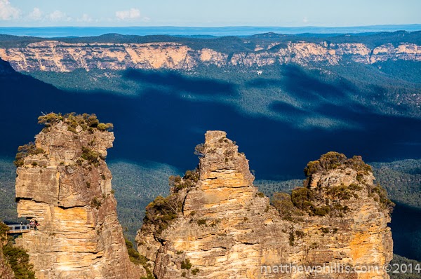
The beautiful 3 sisters in all their glory!
June is the winter soltice in the Southern Hemisphere, the shortest day (or longest night, depending on your perspective!) of the year. All around the nation, people are turning their heaters on, slipping into bed socks, and making chicken soup. It's cold in Sydney right now, but not as cold as Europe of course - but Australia does get cold people! In a small town an hour's drive out of Sydney, people are actually wearing less clothes, hitting streets and celebrating in their own way. Yes, it's Katoomba Magic Festival time again!

The main street of Katoomba on festival day.

Animals hats on adults? You decide.
Some of the costumes at the festival.
The Winter Solstice had been important for people all around the world for a very long time. Typically it was the last feast before the harsh winter sets in. People feasted because they weren't guaranteed to survive the winter - they had to hope they had enough to eat until spring came. Most of the cattle were slaughtered at this time, so they didn't have to be fed, and so this was the only time a year you had fresh meat. There are also many festivities around the world, as this special day has been known for millennia - they still hold a sunrise ceremony at the Stonehenge for example.

Animals hats are fine for children.
That is real hair...
In Katoomba, in the Blue Mountains just outside of Sydney, it is called the Magic Festival, and it kind of like a Medieval Fair on drugs. The main street is closed off to cars, shop stalls are set up, and thousands of people come out all dressed up in weird and wonderful costumes. This year the weather was absolutely glorious - a sunny 19c! I need to remind you that this is the middle of our winter here, and Sydney has been averaging about 22c up until recently - not bad for winter really is it? The mountains are normally colder obviously, but today it turned it on for everyone to enjoy. Usually the weather is bitterly cold - but that has never stopped people coming to the festival.

Horns AND a onesie!
Wow a cape!
The shop stalls sell anything from ales and coffee to healing crystals and wooly hats. It is just fin to walk the streets, look at the people all dressed up, and enjoy the day. It needs to be mentioned though - the question of 'Onesies' and whether they should be seen in public. If you don't know what onesies are, you've been living under a rock, so get out from under it and open your eyes. Onesies are a one-peice baby's jumpsuit made for adults, and come in all shapes and sizes, but mostly in the form of farmyard animals. There were tigers and penguins and others that I just wasn't too sure about. Grown men and women wear these things (and even some celebs), and the question is really should they be? It is one thing to wear at home on the sofa watching TV, sure, but to come out in public? Well, each to their own I guess, but you won't catch me wearing one!

I'm watching you!
Katoomba!
What Katoomba is famous for.
 On any other day, the village of Katoomba is a peaceful and relaxing place. Although it is the mountains, they aren't skiing mountains. Katoomba is at about 1000m, and very different mountains - there are no real peaks, instead just valleys with plateaus sticking out of the green eucalypt forest. The first (European) people to explore and cross the Blue Mountains were a trio of men, Lawson, Blaxland and Wentworth (now town names there). They started out in 1813, as by that time the colony in Sydney had grown rapidly since it's founding in 1788, and needed more farming land to meet it's needs. Their crossing was successful due to a new idea of exploring mountains - previous it had been the English way of following valleys - and this had so far proved futile in Australia. Completed in 21 days, it opened up new farming land for Sydney and founded Australia's first inland city (Bathurst), and the explorers were each granted 1,000 acres of land by Governor Lachlan Macquarie for their services. This is the same Governor of NSW that named everything after his and his wife - Mrs Macquarie's Chair, Lake Macquarie, Lachlan River, Port Macquarie and Macquarie Street in Sydney to name just a few. What an ego!

View of The Blue Mountains from Echo Point.
 Well that's it for another year. Now Katoomba will be returned to it's normal state of relaxation, quiet coffee shops, and artists and people with slightly alternative lifestyles. It is a lovely place, one that I would consider living in if I decided that I needed out of the city. I can quite easily picture myself in my house, looking out over the valleys and breathing in the clean, fresh air. It would have to be green house, solar panels, rainwater collection, the whole deal. Ah but my mind wanders!

Monday, 3 February 2014

Sunday Stroll In The Mountains

The Blue Mountains National Park.
Need to get away from the busy city that is Sydney? Need that 'mini-break' from the rat race? Some people hit the coast for camping and swimming, but there is nothing like the fresh mountain air for me! The Blue Mountains, part of the Great Dividing Range which runs top to bottom all along the east coast of Australia, are only an hour's drive from the heart of the city. There are many pretty little villages to call in at, but my favourite is Katoomba.

The 3 Sisters - Meehni, Wimlah abd Gunnedo.
The witchdoctor turning the sisters to stone.
Frozen forever in stone.
The Blue Mountains are one of the city's top tourist attractions, and are visited by bus loads upon bus loads of (mainly) Korean and Chinese tourists. The reason for this - The 3 Sisters. Not actual sisters, unless you believe the Aboriginal legend. 3 Beautiful sisters fell in love with 3 brothers from another tribe, and wanted to marry them. This of course was against tribal law, as the 2 tribes were feuding - West Side Story style. Anyway, the sisters, Meehni, Wimlah and Gunnedoo, were from the Katoomba tribe, and the brothers (no names, as only the pretty ones are remembered) were from the Nepean tribe. One day, the brothers decided to ignore the law, and tried to steal the woman away, which caused a battle between the tribes. A helpful witch doctor from the Katoomba tribe took it upon himself to help, and so turn the sisters into stone, to protect them from harm. Unfortunately the good doctor took a spear, or possibly a boomarang, to the head (maybe) and died. As only he could reverse the spell, the 3 sisters remained as they were, and now stand at Echo Point, a short distance from the village of Katoomba.

Katoomba Station - your ticket to fresh mountain air!
Normally I drive up, as it's quick and convenient, but this time I was going with my English class, and decided on the train for the relaxing trip and the view along the way. That and my class wouldn't have fit in my little clown car... The train from Central takes 2 hours, running from the CBD through the Western Suburbs and over the Nepean River which marks the edge of Sydney. You can fully appreciate what a big city it is on this trip, as it seems to stretch forever and it gets your full attention as you're not battling the traffic. After crossing the river, the train snakes it's way up the mountain, 1000m above sea level, and through small towns and villages, following the highway. Getting out at Katoomba station, you are immediately hit with fresh air, quiet streets and a more subdued pace to life - just the way I like it!

The 3 Sisters from Echo Point.
The original 1950s cable car, which the Orphan Rocker's rails in the background.
The view from Scenic World.
Most people head straight for Echo Point and the 3 Sisters, and I don't blame them. There is much more to see in the area, but who doesn't want to see 3 900m tall women? There are all throughout the National Park, but as the stairs had been damaged in a recent landslide, we were limited to walking along the cliff-top. This trail, hugging the cliff on one side and looking down to a 300 meter drop on the other, is the best way to see it - not in a car. An easy walk though! We walked from Echo Point to Scenic World. This place, built in 1958, is still running and now bigger than ever. Originally it ran the Scenic Skyway, a cable car that goes right out over the valley and offers a stomach dropping view. Before it opened up as a tourist attraction, it had a 'railway' to haul up coal, which later became the Scenic Railway. This railway is one of the steepest cable-driven funicular railways in the world at a gut wrenching 52 degrees incline!

The Skyway going over the valley and past Orphan Rock.
The first Sister, and the only one you can get on.
In 2004 they replaced the old Skyway car with a brand-newie - yes, they had been running that old bucket for nearly 50 years... and yes, I did go on the old one, but haven't been on the new one - I don't think it would be the same! In 1984 they started building a roller coast here, called the Orphan Rocker, which was to run around the cliff face, and hammer around corners and scare the life out of people with its rails going within a meter of the 300m straight-down drop. It never opened sadly, but you can still see the train running around the grounds, and they are still talking about finishing it... not that I would ever go on it!!

As we didn't have a car, we had to walk everywhere. This wasn't a problem, but the weather was very warm, so it was a bit tiring. We stopped off for lunch back in the village (as I hate paying Tourist prices!). Katoomba is a chilled out place, with some trendy cafes and arts & crafts shops as well as a few antique stores too. If you look closely enough, you can tell that the village had it's hay day in the 20s. Neo-Gothic 20's buildings can be seen, an old cinema which is now a cafe serving all-day breakfast, to the more obvious Carrington Hotel - a grand old building restored in 1998 to it's former 'Outlook Hotel' style grandness. It was first built in 1883 and served the wealthy Sydney folk with somewhere to get city comforts in a country setting - Im happy that its back, even if I can't afford to stay there.

The Blue Mountains - one of my favourite places in the world.
 The day was drawing to an end, and so we had to hit the stations and jump back on the train, back to the rat race of the Big Smoke. It was a lovely day out, and it was great to share it with my students - I am so happy that they make the most of their time in the country by going out and doing this all the time, and even spending a bit of time with their (cool) teacher! Thanks guys!!

My and my cool students! 

Sunday, 26 January 2014

Australia Day in Sydney

The HMAS Bounty.
Does my make-up look ok?
Australia Day is a day that the Nation celebrates on the 26th of January. It is a proud day, a day when everyone gets together to celebrate the things that make up this wonderful country. Multiculturalism, diversity, culture, and of course the beautiful and unique landscape of Australia. Although it should be a day of celebration for everyone, it was marred this year by some racist and cowardly graffiti in Melbourne as well as Botany Bay in Sydney. I won't waste time on these events, as they are truly low and not worth mentioning again.

Tall ships in the harbour.
Waking up this morning, knowing what day it was and how much I wanted to be a part of it, still didn't make it easy getting out of bed. It wasn't the fact that I was out till 3:30am at a friends birthday, but more to do with the weather - it was grey, a little chilly, and threatening to rain. It only happens once a year, and considering I haven't been in the country to celebrate it for 7 years, I headed out into the city despite my initial hesitation.

Happy Australia Day!
There was something to be thankful for regarding the weather - the foreshore didn't have it's usual festival 'sardine can' feel about it. People were out and about, dressed in Ozzie flags and temporary tattoos in place, but there just weren't that many of them. The few that were there were rugged up and bravely facing the weather - reminding me of the English at 'the seaside' - too cold and windy to be doing it, but it's summer, and that's what you do in summer! I managed to get a good front-row position under the bridge for the Sydney ferry race. The fire boat started the race, kind of like the lap car in a motor race, but spraying huge jets of water into the air, and nearly making itself disappear it it's own mist. The ferrys were all the same, apart from the sponsor's logos all over them, but it was fun to watch.

A young Ozzie.
An older Ozzie.
Apart from the Harbour activities, there was plenty more going on today. Unfortunately I didn't have the stamina to do an all-dayer in this weather, so I left it on a high note. I did see people with paint still on them from the 5km 'fun-run' Colour Dash through the city. Participants start the 'race' with a complementary white t-shirt, and as they pass through different colour stages, volunteers through paint balls at them. After 5 kms of this, you can imagine the state you end up in! All in good fun, and raising money for MS (Multiple Sclerosis).

People watching the ferry boat race.
It was a good half-day out, and it has been a pleasure to be a (small) part of Australia Day at home. I have spent many Australia Days in different parts of the world, and you wouldn't even know it from a normal working day. Here, there is something happening all the time, all day. It is also the only day of the year that the game 'Two-up' is allowed to be played and bet on.

2 blokes getting into the spirit of it!
An aboriginal dance being performed.
We're all Australian!!
 To finish off, I would like to say something on a very touchy subject. To some people, it is not 'Australia Day,' but 'Invasion Day.' On this day, in 1788, the First Fleet arrived in Sydney harbour and raised the British Flag, claiming New Holland in the name of King George. From that point, the native people of Australia were mistreated, killed and had their children stolen, just to name a few injustices. Australia has had it fair share of internal conflict, wrongs, and mistakes, but a huge step was made in 2008 when the then Prime Minsiter Kevin Rudd said the all important words "I'm sorry" for the Government and the Nation as a whole. Whatever happened in the past, there comes a time to forgive the past, reconcile, and move on together. Australia Day is a day for ALL Australians, no matter where they were born or grew up, but consider this country their own.

If only more strangers hugged each other, we would have less problems in the world! Great work!!


New Zealand Southland - Part 2

 Live the van life while you have it – no regrets The landscape on the South Island is simply stunning The view from Mount Cook road This wa...